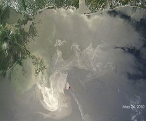
 Washington DC (SPX) May 28, 2010 - Two NASA satellites are capturing images of the oil spill in the Gulf of Mexico, which began April 20, 2010, with the explosion of the Deepwater Horizon oil rig.
This series of images reveals a space-based view of the burning oil rig and the ensuing oil spill, through May 24.
rest http://www.spacemart.com/reports/NASA_Satellites_View_Of_Gulf_Oil_Spill_Over_Time_999.html

No comments:
Post a Comment